To our surprise, most of the weather during our week at latitude 68* N was sunny and 60+F. Temperate, considering we were 3 degrees above the Arctic Circle. The Gulf Stream keeps the Lofotens warmer than other similar latitudes. We discovered it can rapidly change.

Arctic Sky, 40.3 Delphia, in Svolvaer
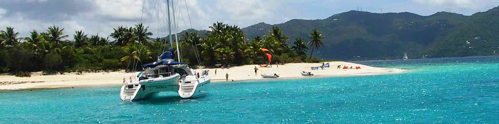
Boarding midway up the Lofoten Island chain at Svolvaer, the crew provisioned for good meals aboard our Delphia 40.3 sloop, ‘Arctic Sky’. Svolvaer is one of the larger towns in the Islands with a population of about 4500 that swells in the summer. You can fly to Svolvaer from Bodo or take a ferry from several mainland coastal towns.
Fishing is the local industry of the Lofotens. The ports are fishing villages. Like Svolvaer, some have grown to accommodate tourism: hiking, biking, kayaking, skiing … and sailing. Small ports remain fishing villages recognized by the little red “rorbues”; traditional fishermen’s cottages and housing for fish processing. Some are converted to lodging and often have amazing sea views. In 1120, King Øystein built “rorbu” cabins in Lofoten to attract fishermen with a place to live and work – later taxing them. It’s good to be King!

Lofoten Islands Sail Itinerary
Lofoten is a ‘Land of the Midnight Sun’. Artists come to Lofoten for the unique light and fantastic geography of mountains and fjords. Several ports we visited have museums and art galleries.
We embarked about 3 pm on Friday and decided for a short sail east to Skrova Island to shake out the sails, get familiar with the lines and limber up the crew.

Svolvaer, Lofoten Islands, Norway
Arctic Sky is well-rigged with plenty of sail; double reefed with lines coming to the helm from luff and leach. She also had good storage and lots of light in the interior.
We sailed to the winding inlet leading into Skrova Harbor, an old whaling port, for our first overnight. The public pier is near fishing cottages, the local restaurant and has electric hook-up; unusually free of charge.

Arctic Sky at Skrova Pier
The pier was full but a local sailboat skipper kindly let us raft up for the evening. He gave us helpful tips; the local restaurant had whale meat for dinner, and, a friendly Norwegian custom is to board another boat to steal its pirate flag! – “Really!? “Yah, just for fun.”
Forgoing the whale meat, we cooked on board delicious cod and mackerel caught by the crew. Each evening, I lowered our flags.
Saturday we pointed Arctic Sky north past several groups of small islands, up the Raftsundet Channel separating the two main Lofoten islands, Ausvagoya and Hinnoya. Most of the 18 NM to the small fjord, Trollfjorden, is no problem but there are a few tricky bits of shallow, narrow passages between treacherous rocks. Legend has epic Viking battles fought in Trollfjorden. Its steep mountain sides, 1 NM length with 100 m. wide entrance forms a dramatic stage for imagining these exploits.

The Trollfjorden fjord
We moored at work pier near the water sluice and loosely looped lines fore and aft and with spring lines. Loosely because the lines need to ride up and down the posts during the 9 ft. tidal flow!
The fjord was glassy smooth so two intrepid crew took the dinghy for an exploration of the shoreline and local birds. On their return they claimed to have seen four waterfalls! We had a calm overnight within this geological wonder interrupted only by the arrival of the large Hurtigrute cruise ship that miraculously turned 180* in the narrow fjord about 200 meters from us. Good bow thrusters!
Heading south Sunday morning, we took the easterly route down the Raftsundet to avoid the narrows and hopefully gain any wind from the east. We had 22 NM to cover by late afternoon in order to have a selection of moorings at Henningsvaer.

Leaving Trollfjorden
Winds remained light as we cruised southwest. Green islands with rocky peaks on our starboard and the coast of Hinnoya Island to our port. Passing Brettesnes, Store Molla Island, we exited the Raftsundet to the broader Vestfjord, the sea between the Lofotens and Norway’s mainland coast. We still had lots of islands to negotiate before the open water so rather than continue south to round them, we cut through the narrow channel north of Skrova Island towards the open Vestfjord.
Henningsvaer is two long, thin islands separated by a narrow waterway. Each side of this channel is packed with fish houses and processing sheds, restaurants and a few hotels. We wanted to moor mid-channel at the Bryggehotel pier but a steel hulled 60 ft ketch had taken up too much space. Nice yacht but bad parking. Luck was with us though because the floating public pier at the foot

The channel of Henningsvaer
of the channel gave us a great view of the whole waterway. The left side has the galleries and restaurants, the climbing school, shops and the hotel while the right side was mostly fish processing buildings. The quieter right side did have one restaurant … where I had a tasty whale steak.
The forecasted rain and heavy wind arrived during the night so we waited Monday morning until 11 am to leave the pier. Taking the southern channel out of Henningsvaer, we steered SW around several groups of small islands and raised sails in 5 ft. waves and 25 kn of wind. Double reefed, Arctic Sky sailed happily at 6-7 kn. After an hour, the wind dropped so we shook out one reef and had an excellent 2 hr. sail in 15 + kn wind and diminishing waves to Stamsund.

Stamsund fish houses
A working fishing village with some large fish processing houses, Stamsund has a nice 50 m. floating pier in front of the Skjaerbrygge restaurant. We moored Arctic Sky, plugged in, turned on the heater. The crew took advantage of the clear evening to wander about the small town. I took advantage of the Skjaerbrgge for a cold beer and a comfortable chair by the fireplace.
Wednesday morning had some light mist and rain. We filled the water tank and enjoyed a late breakfast aboard Arctic Sky. About noon we dropped the lines for our last southerly sail towards Nusfjord, about 15 NM. Another super sail for 3 hrs with 12-15 kn of wind on a broad or beam reach doing 6- 8 kn of speed with some tidal push.

Nusfjord Harbor with Arctic Sky center back
Nusfjord is tiny. The harbor is about 200 m. long and less than two boat lengths wide. The floating pontoon is low: “all starboard and drop those fenders!” With little room to maneuver, easing Arctic Sky to the mooring with wind on the beam was a bit tricky. The crew handled her well and we were tucked in for the night.
Archeologists claim that Stone Age Lofoten fishermen used tackle like stone sinkers and hooks made of horn and bone. Later, the deep sea haul was taken with simpe hook and line – handlines. This continued for

Cod fish heads, very dry.
a few years into the Middle Ages. Lofoten fishing history is somewhat cantankerous; the various competing types of tackle caused inter-village unrest. In 1644, King Christian IV banned longlining. Gillnets were introduced about 1750. In 1816, the Lofoten Act regulated when fishing could begin each morning and divided the seas into areas for longlining and gillnetting. The 1938 Raw Fish Act ensured fishermen a fixed price by the Raw Fish Sales Association. Today, the sea off Lofoten is divided by the fishermen into longline, gillnet and seine areas during the winter season. The handliners can fish where they wish.
A ubiquitous sight along the islands are large fish drying racks. Miles of them. Nusfjord , a fishing village for a thousand years, is all about cod: cod meat, cod cheeks, cod tongues, cod liver oil. A less usual sight was the rack of dried cod heads

Looking East from Brettesnes
hanging along the walkway to the general store. Perhaps 1000 years old and looking like a medieval warning to cod.
We had 30+ NM to cover in two days so we were off the pontoon at 9 am. Light winds gave us enough to sail NE for an hour; then we had to motor-sail to stay above 4 kn of speed.
We decided on a secluded anchorage for our last overnight. The sailing guides and suggested itineraries did not offer any on our route so we were leaving time to check out a couple of spots shown on the charts and my Navionics. With the wind rising and dropping, we made sufficient time to look at the large group of islands south of Valberg, 18 NM from Nusfjord.

View from shore of Brettesnes anchorage
The channels through the islands were tricky; narrow and shallow. We found one suggested anchorage but it was rather tight, little room to swing with rocky islands in all sides but south. And the wind was forecasted from the south so not very good protection.
We left the warren of rocky islets and cruised across the broad waterway separating Vestvagoy from Austvagoya. Heading 8 NM north of Henningsvaer, we cruised up the channel leading to Brettsnes. (Not the one on Store Molla Island mentioned above, this one is on Austvagoya Island.) Our exploring paid off; a beautiful, well protected anchorage.

Lofoten coastline heading NE to Svolvaer
No other sailboats, only a few small craft on a campground dock. Mountains to the north, east and west with a view across some low ground to the mountains further south. Perfect!
We had a late morning start to cover the remaining 15 NM to Svolvaer. Using occasional motor assistance, we sailed 3.5 hrs to Svolvaer’s inner harbor to refuel while enjoying the mountain scenery along the way. The sun was out, another 60* day. One of the crew was stretched out on deck taking the sun. Three degrees above the Arctic Circle!